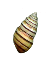
The Liguus
of Cuba, adjacent Keys
and Isle of Pines
Return to Cuban Liguus Taxonomy Listing
|
|
|
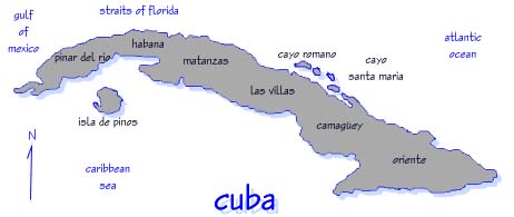
Map of Cuba and important surrounding keys and islands |
Discussion of the Cuban Liguus Locality Data
The following data is based upon the History of Cuba and translation of the locality
nomenclature from Spanish to English. It is organized in a glossary like format, That is,
the word or name followed by the translated meaning (not literal) as used in Cuba.
Provincia: Province, equivalent to a US County. Cuba was divided into six Provinces
pre 1959. At present some have been re-named and new ones added.
Municipio: Municipality or township.
Central: Short for "Central Azucarero" or sugar mill. Name is derived from the hub of
narrow gauge rail harvesting systems. All the Centrales have been re-named post 1959.
Finca: A farm or ranch. The word "rancho" is used in Cuba for an open roofed area.
Cordillera: Range of hills or lesser mountains.
Sierra: Range of mountains or larger hills.
Mogote: Limestone outcroppings in the Province of Pinar del Rio.
Hoyo: Literally, hole. Named depressions, small valleys areas between hills or mountains.
Cayo: Double meaning! Cayo means key (small island) but is also used to denote mainland patches of forest as "Cayo de monte" or sometimes named patches as "Cayo (name)".
Loma: Hill.
Monte: Forest or woods.
Ensenada: Shallow bay or gulf.
Bahia: Bay
Cabo: Point of land
Vega: Tobacco plantation
Colonia: Sugar cane plantation
Note: To study the geographical distribution of the Cuban Liguus any maps used as
references should preferably be pre 1959 because of the place-name changes
effected since the original descriptions were developed. Many of the place-names,
specifically for small hamlets or villages do not appear on any map and one must
obtain geographical placement/direction from locals.
Return to Cuban Liguus Taxonomy Listing